The Earth in 2022: The latest (cloud)free satellite map is waiting for you!


The global and cloudless Sentinel-2 map, crafted by EOX.

Play the EO-Guesser game and explore beautiful locations!

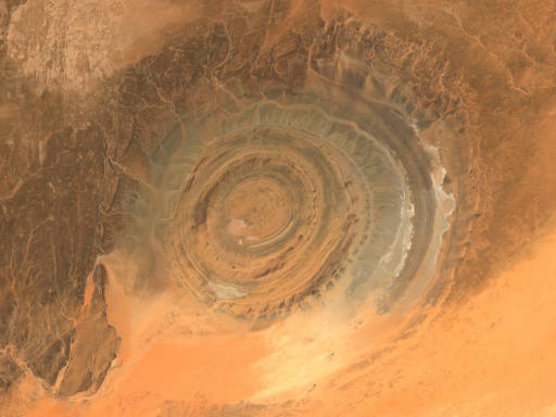
Richat Structure, Mauritania in 2022

Clearing up the weather

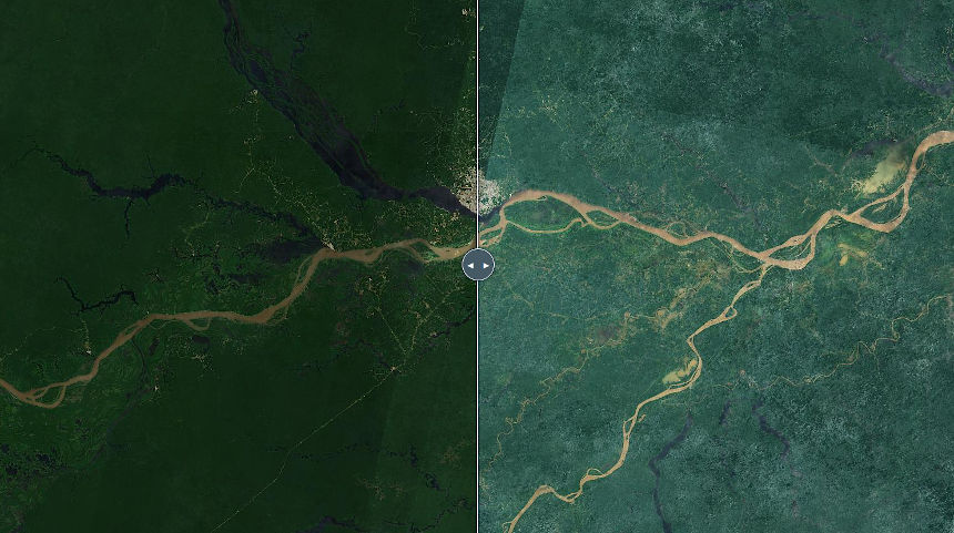
Endless sunshine, eternal summer - the Sentinel-2 cloudless layer combines trillions of pixels collected during differing weather conditions during the whole year of 2022 and merges them into a sunny homogeneous mosaic, almost free from satellite and atmospheric effects. Our thanks go to the European Commission and the European Space Agency for the free, full, and open Sentinel-2 data.
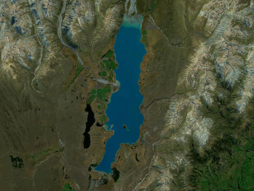
Lake Tekapo, New Zealand in 2022

Improved results

Less Clouds, Less Stripes: Bottom of the atmosphere and bidirectional reflectance distribution corrected (BRDF) data were used to make mosaic purely from the acquisitions taken in a single year gives you the opportunity to buy and use an unique satellite map.
Better Post-Processing: Sharper look, more balanced colors - our improved post-processing yields much better results in the various environments.
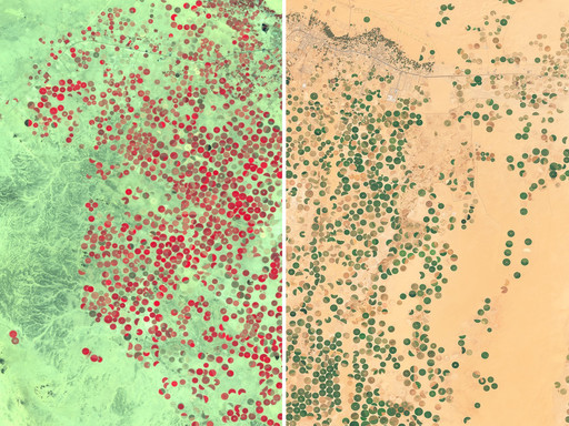
Examples for different usecases of Sentinel-2 data

Custom Solutions

Interested in cloudless satellite imagery or custom processing? EOxCloudless preprocesses raw satellite imagery to cloudless and seamless satellite data coverage. No more manual preselection of good scenes. No more unnecessary fetching of unusable data. No more data stitching. Just define time of interest and let us do the work.


Creative Commons License

Free to use!

You are free to use Sentinel-2 cloudless as long as you follow the applicable license conditions. The conditions for use are the attribution when publishing any imagery or content from Sentinel-2 cloudless as well as the non-commercial use for the 2018 - 2021 data. The attribution shall be displayed legibly and in proximity to the usage, in on-line publications (social-networks etc.) it shall include the links and show the text as described below.

Creative Commons License

Sentinel-2 cloudless 2022 by EOX IT Services GmbH is licensed under a Creative Commons Attribution-NonCommercial-ShareAlike 4.0 International License. The required attribution including the given links is "Sentinel-2 cloudless - https://s2maps.eu by EOX IT Services GmbH (Contains modified Copernicus Sentinel data 2022)"

Sentinel-2 cloudless 2021 by EOX IT Services GmbH is licensed under a Creative Commons Attribution-NonCommercial-ShareAlike 4.0 International License. The required attribution including the given links is "Sentinel-2 cloudless - https://s2maps.eu by EOX IT Services GmbH (Contains modified Copernicus Sentinel data 2021)"

Sentinel-2 cloudless 2020 by EOX IT Services GmbH is licensed under a Creative Commons Attribution-NonCommercial-ShareAlike 4.0 International License. The required attribution including the given links is "Sentinel-2 cloudless - https://s2maps.eu by EOX IT Services GmbH (Contains modified Copernicus Sentinel data 2020)"

Sentinel-2 cloudless 2019 by EOX IT Services GmbH is licensed under a Creative Commons Attribution-NonCommercial-ShareAlike 4.0 International License. The required attribution including the given links is "Sentinel-2 cloudless - https://s2maps.eu by EOX IT Services GmbH (Contains modified Copernicus Sentinel data 2019)"

Sentinel-2 cloudless 2018 by EOX IT Services GmbH is licensed under a Creative Commons Attribution-NonCommercial-ShareAlike 4.0 International License. The required attribution including the given links is "Sentinel-2 cloudless - https://s2maps.eu by EOX IT Services GmbH (Contains modified Copernicus Sentinel data 2017 & 2018)"

Creative Commons License

Sentinel-2 cloudless 2016 by EOX IT Services GmbH is licensed under a Creative Commons Attribution 4.0 International License. The required attribution including the given links is "Sentinel-2 cloudless - https://s2maps.eu by EOX IT Services GmbH (Contains modified Copernicus Sentinel data 2016 & 2017)"

Feel free to use the provided service endpoints (WMTS or WMS) directly in your application. You may also download the data as rendered image mosaics directly from these services or more conveniently from our Sentinel-2 cloudless Download Service. Just make sure to follow the license conditions which are the attribution requirements for the corresponding year and non-commercial usage (2018, 2019, 2020, 2021 & 2022). The maximum request size is limited to 4096px, but you may stitch multiple requests to fit your needs.

If you are looking for the original GeoTIFF files from 2016 instead, have a look at this blog post. You may download the data as source GeoTIFFs from the AWS S3 bucket eox-s2maps in the eu-central-1 region. Warning: AWS may charge you for download bandwidth.

Please get in touch if you need anything else.

Like what we do? Show some favorite

By choosing a payable product in our EOxCloudless offer, you're helping us to run and improve the free Sentinel-2 cloudless! EOxCloudless offers for example various commercial licenses for our off the shelf data as well as custom tailored exploitation-ready satellite imagery as described below.


EOxCloudless Logo

Exploitation-ready Satellite Imagery

Sentinel-2 cloudless is part of the EOxCloudless Product Family, which offers source data for viewing and analysis.

Viewing Products

Get our prerendered Sentinel-2 cloudless as map cache or create your own layer using our mapping optimized source mosaics for web maps or desktop GIS tools.

See EOxCloudless Viewing Products

Data Products

Get off-the-shelf multispectral mosaic data from Sentinel-2 or define a custom mosaic tailored for your needs for further analysis and processing.

See EOxCloudless Data Products


Our products include:

  • Sentinel-2 cloudless single-file products (GeoPackage or MapCache SQLite files)
  • Sentinel-2 cloudless compressed & lossless GeoTIFFS (RGB or RGB/Nir)
  • 2016 - 2022 global Sentinel-2 data products
  • Additional sensor data (Sentinel-1 and more)
  • Fast & scalable custom processing options with additional parameters

Visit the EOxCloudless website for examples and more information!


Media coverage

Over 2 000 000 map tiles served each day

70 000 visitors per month

1:47 minutes average visit duration

tagesspiegel.de - Längste beheizte Pipeline der Welt - Ölbrunnen im Nationalpark

heise.de - ESA-Satelliten liefern Daten für Satellitenkarte der Welt ohne Wolken

dailymail.co.uk - A cloudless Earth: Stunning interactive 80 TRILLION pixel image reveals an unprecedented clear view of our planet

iflscience.com - Check Out This Stunning 80-Trillion-Pixel Cloudless View Of Earth
Over 38.000 shares

hvg.hu - Készült egy 80 000 000 000 000 pixeles fotó a Földről, itt megnézheti

index.hr - Snimka od 80 trilijuna piksela: Planet Zemlju nikad niste vidjeli na ovakav način

galileo.tv - ZOOM DICH HIER DURCH EINE 80-BILLIONEN-PIXEL-KARTE UNSERER ERDE

refresher.cz - Vznikla mapa světa v rozlišení 80 bilionů pixelů. Evropské satelity ji společně vytvářely jeden rok

virality.hu - 80 billió pixeles fotó készült a Földről – itt nézheted meg

tech.sme.sk - Družice zachytili Zem v úžasnom rozlíšení bez oblakov

vecernji.hr - Snimka od 80 trilijuna piksela: Ovaj pogled na Zemlju ostavlja bez daha

expres.sk - CELÁ ZEM AKO NA DLANI NA JEDNEJ FOTOGRAFII. NÁJDETE NA NEJ SVOJ DOM?

androidportal.zoznam.sk - Toto musíte vidieť! Nádherný záber na Zem s rozlíšením neskutočných 80 biliónov pixelov!

playtech.ro - Imaginea de 80 de trilioane de pixeli care surprinde Pământul în toată splendoarea sa

agora.md - Imaginea de 80 de trilioane de pixeli care surprinde Pământul în toată splendoarea sa

mojandroid.sk - Neuveriteľný záber! Pozrite si 80 biliónov pixelovú fotografiu Zeme

gisandbeers.com - Sentinel 2 Cloudless: imágenes Sentinel libres de nubes

nationalgeographic.com.au - WHAT DOES EARTH LOOK LIKE IN 80 TRILLION PIXELS?

chip.de - Sentinel-2 cloudless - 80 Billionen Pixel Weltkarte

vecernji.hr - Snimka od 80 trilijuna piksela: Ovaj pogled na Zemlju ostavlja bez daha

player.hu - Nézd meg az Európai Űrügynökség 80 billió pixeles képét a felhőtlen Földről!

turistamagazin.hu - ILYEN A FÖLD 80 BILLIÓ PIXELBEN AZ ŰRBŐL

moya-planeta.ru - Создано первое безоблачное изображение Земли

tekniikanmaailma.fi - ”Maailman ensimmäinen pilvetön mosaiikkikuva” maailmankartasta julkaistiin – lähes 80 767 miljardia pikseliä

fakulteti.mk - СНИМКА ОД ЗЕМЈАТА КАКВА ШТО НЕ СТЕ ВИДЕЛЕ ДОСЕГА

nyteknik.se - Rymddata visar jorden i 80 biljoner pixlar

letemsvetemapplem.eu - Podívejte se na fotografii světa, která se skládá z 80 bilionů pixelů

revistagalileu.globo.com - Mapa da Terra sem áreas cobertas de nuvens é impressionante

webtekno.com - Dünya’nın 80 Trilyon Piksellik Eşsiz Görüntüsü Yayınlandı!

ansa.it - La mappa della Terra senza nuvole

techbox.dennikn.sk - http://techbox.dennikn.sk/eox-vytvorila-snimku-zeme-s-extremnym-rozlisenim-80-milionov-megapixelov/

derStandard.at - https://derstandard.at/2000065006974/Mysterium-in-Israel-Kopflose-Kroeten-in-4-000-Jahre-altem?_slide=5

galiciaconfidencial.com - http://www.galiciaconfidencial.com/noticia/70058-espectaculares-imaxes-satelite-cidades-galegas

mapa.targeo.pl - https://mapa.targeo.pl/21.2239672,51.9759025,22

and many more ...